Navigation, offline maps, and more on the free Roam app.
Get the AppYankee Hill Summit Climb
No elevation data available
Description
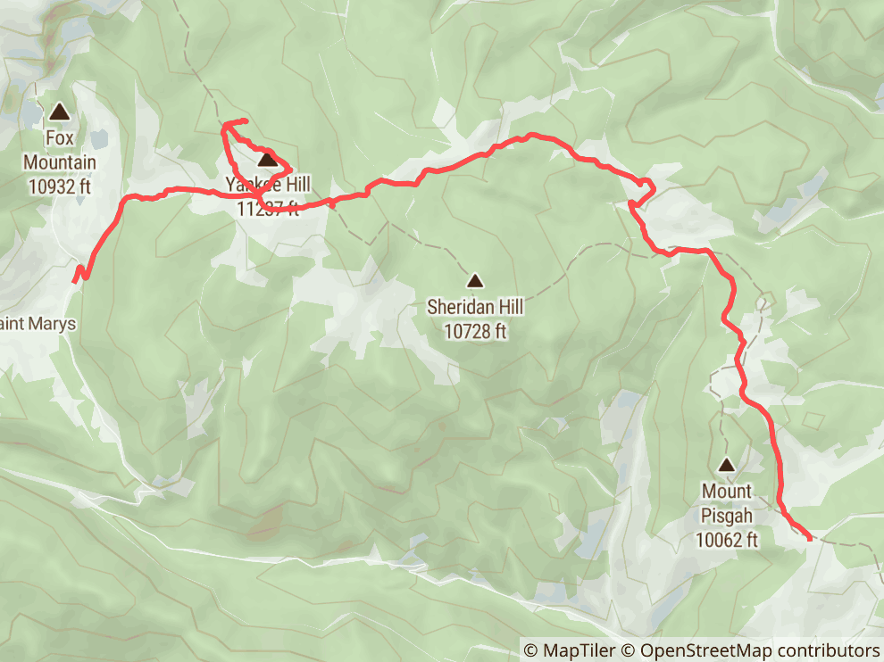
Yankee Hill offers a classic Colorado off-roading experience through a historic mining area near Idaho Springs and Central City. This network of trails, often referred to as Yankee Hill Road or the Yankee Hill Trail System, features a mix of dirt, gravel, and notably rocky surfaces. You can expect steep climbs, some rock gardens, and potential water crossings, with options for various skill levels. The main routes are generally moderate, suitable for stock high-clearance 4x4s, but more challenging sections and optional lines exist for those seeking a tougher adventure. The area boasts incredible high-alpine scenery, including views of prominent peaks like James Peak, Mt. Bancroft, and Mount Evans from the Yankee Hill summit. Navigating the maze of trails can be tricky, so a GPS is highly recommended. The trail system is part of the Arapaho National Forest and provides access to old mine tailings and remnants of the area's rich mining past. Dispersed camping is available in some areas, but be mindful of private property.
Directions
Yankee Hill has multiple access points. A common western approach is via Fall River Road (CR 275), north of Idaho Springs. West End Start (via Fall River Road): From I-70, take Exit 238 for Fall River Road (CR 275) just past Idaho Springs. Drive north on Fall River Road for approximately 8.5 miles and turn right onto Mine Road. This leads into the Yankee Hill trail system. An alternative start via Cumberland Gulch is to bear right where a switchback swings left, about 7.0 miles up Fall River Road. East End Start (via Central City/Black Hawk): From Black Hawk, head southwest on Gregory Street (which becomes Lawrence Street). After 0.5 miles, continue onto Eureka Street. After another 0.5 miles, turn right to stay on Eureka Street. Continue 0.3 miles to CR 3/Upper Apex Road. After 0.4 miles, turn left onto CR 1-N/King Flats Road. Go 1.6 miles to a bend in King Flats Road and continue straight onto Bald Mountain Road. Follow Bald Mountain Road for 1.9 miles to an intersection. Take the right fork to head north on CR25/Pisgah Lake Road, which is part of the Yankee Hill network. A GPS is highly recommended as the trail network can be confusing.
Difficulty
Yankee Hill is generally considered a moderate trail network. Most routes can be handled by a stock high-clearance 4x4 vehicle with a capable driver. You'll encounter sections of dirt, gravel, and notably, rocky areas. Expect some steep climbs and descents. There are 'chewed up' rocky sections, particularly in the middle of some routes, and some parts can be narrow. While there are no extreme, vehicle-damaging obstacles on the main routes, careful tire placement is often needed. Optional, more challenging lines and hill climbs exist for those looking for a tougher experience. The biggest challenge for many is navigating the extensive network of trails, so be prepared for that. Some users have found certain sections surprisingly intense with rocks and obstacles, especially if attempting more difficult spurs or if conditions are poor.
Trail Uses
- Off-Road Vehicles
- 4x4 Vehicle
- All-Terrain Vehicle
- Motorcycle
- Snowmobile
Recent Adventures

Yankee Hill
EPIC VIEWS
The text and geometry of this object available under the Creative Commons Attribution-ShareAlike 4.0 license